
Marvão
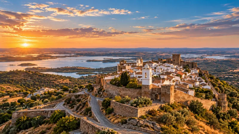
A granite hilltop town in Portugal's Alto Alentejo, Marvão grew around a castle on a quartzite ridge of the Serra de São Mamede, close to the Spanish border. Its walled streets, defensive architecture and mountain setting tell the story of a place built as much for protection as for living.
Marvão is a small town in the Alto Alentejo region of Portugal, built on a rocky ridge a few kilometres from the Spanish frontier. Its castle, its steep medieval streets and its position high in the Serra de São Mamede have long made it both a strategic defensive site and, on a modest scale, an administrative centre for the surrounding countryside. Around three thousand people live in the whole municipality, and only a few hundred within the old walls, so the place retains the proportions of a village even though it has the buildings and institutions of a historic town.
Location and general character
Marvão lies in the district of Portalegre, between Castelo de Vide and Portalegre, and within a short drive of Valencia de Alcántara on the Spanish side of the border. The town occupies a quartzite crest at roughly 850 metres above sea level, at the northern end of a long ridge. The ground falls away sharply to the north, south and west, so the only easy approach is from the east, and it was in that direction that the settlement gradually spread. This natural arrangement of rock and slope explains almost everything about the town's layout: the walls follow the edge of the crag, the streets run east to west along the spine of the hill, and the view opens out in three directions at once.
The municipality covers about 155 square kilometres and is divided into four civil parishes: Santa Maria de Marvão, São Salvador da Aramenha, Santo António das Areias and Beirã. Most residents live in the lower, more sheltered parishes, where olives, cork and chestnuts are grown. Up on the ridge, winters are colder and wetter than on the plains below, and the exposed summit can feel raw even when Portalegre is mild.
From Moorish refuge to border fortress
The earliest occupation of the site is obscure, but by the ninth century the crag had acquired the name it still carries. According to tradition, the rebel leader Ibn Marúan, who had fallen out with the authorities in Mérida, established a refuge here around 876–877, and the place became known as Amaia de Ibn Marúan. Below the ridge lay the much older Roman town of Ammaia, whose ruins and museum can still be visited near São Salvador da Aramenha; the medieval stronghold effectively replaced it as the focus of local power.
Christian forces under Afonso Henriques took the position in the 1160s, and it was later entrusted to the Templars. Sancho II granted the settlement a charter in 1226, and Marvão's fortunes were closely tied to the quarrels of the Portuguese crown: King Dinis seized the castle from his brother Afonso in 1299 and began the great square keep the following year. A new charter from Manuel I in 1512 left its mark in the pillory and the royal arms on the town hall. Fernando I had already declared the place a couto de homiziados in 1378, a sanctuary where fugitives enjoyed protection, and in the sixteenth century it attracted Jewish refugees from Spain. Later conflicts brought repeated sieges and occupations, including Spanish assaults during the Restoration War, the taking of the fortress in 1704 and its recovery in 1705, French occupation during the Peninsular War, and fighting in the Liberal Wars of the 1830s. The castle was classified as a national monument in 1922, by which time the town had long since settled into the quiet garrison role that shaped its modern appearance.
Walls, streets and granite architecture
The defences are unusually complete and read as three concentric lines. The inner circuit, dominated by the keep, encloses the citadel; a middle line of massive towers and battlements follows it; and an outer barbican connects to the long wall that wraps around the whole hilltop and takes in the town. Gates pierce these walls at the few points where the slope allows access, and the main street climbs from the eastern entrance between houses built of coarse local granite.
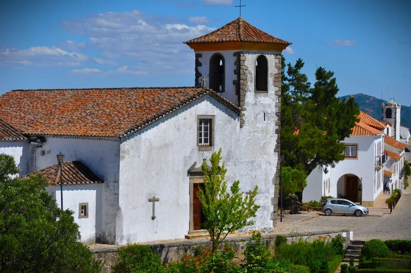
Within the walls the architecture is domestic rather than grand. Doorways are framed by Gothic arches, windows carry Manueline mouldings, and wrought-iron balconies sit above doorways in the manner typical of the Alentejo. Whitewash and stone alternate along the narrow lanes, and the small scale of the houses gives the streets a shaded, tunnelled quality in summer. The buildings date mainly from the fifteenth to the eighteenth centuries, with later repairs in the same materials, so the town reads as a single piece of construction even though it was built over several hundred years.
The Serra de São Mamede and the surrounding landscape
Marvão sits inside the Serra de São Mamede Natural Park, established in 1989 to protect a range that rises to just over a thousand metres and forms one of the most distinctive uplands in southern Portugal. The slopes below the town are covered with cork oak and holm oak woodland, chestnut groves and terraced olive yards, with rocky outcrops and streams in the gullies. The park is known for its birds of prey, including griffon vultures and eagle owls, and for amphibians that breed in its ponds and watercourses; the castle itself was once nicknamed an eagles' nest because birds nested on its towers.
Directly beneath the western cliffs runs the river Sever, an unusual stream that flows from south to north before joining the Tagus. For much of its course it marks the frontier with Spain, and the valley it has cut provides the dramatic foreground for the views from the keep and from the belvederes along the walls.
Local culture and everyday life
Life in Marvão is shaped by agriculture and by the seasonal rhythm of visitors. The municipality's population is older than the national average and has been falling for decades, as it has across the interior of the Alentejo, and a large share of the housing stock is used as second homes. Weekday mornings are quiet: deliveries, a few cars, conversations in the square. Regional cooking draws on what the land provides — pork, bread-based dishes, chestnuts, olive oil and mountain cheeses — and the chestnut harvest is the occasion for the town's main annual gathering in November, when growers and visitors fill the streets.
The municipal museum, housed in the former Igreja de Santa Maria, holds sacred art, local finds and material recovered from the Roman city of Ammaia, tying the hilltop town to the valley it once controlled. Religious feast days, the procession routes between the parish churches and the small cemetery outside the walls remain part of the calendar.
Notable places in the town
Few settlements of this size contain so much within a short walk. The castle and its keep dominate the highest point, and the terrace below the walls gives a wide prospect over the plains towards Spain. The Igreja de Santiago, the Renaissance Capela do Espírito Santo of 1573, the pillory and the town hall with its royal coat of arms stand along the main street, while the small Calvário chapel of 1804 marks the edge of the built-up area. Outside the walls to the south-east lies the Franciscan Convento de Nossa Senhora da Estrela, founded in 1448 and altered in the sixteenth to eighteenth centuries, long associated with the town's devotion to its patroness.
Nearby destinations
The Roman site and museum of Ammaia, a short distance down in the Sever valley, complement any visit to the town and explain its earlier history. Castelo de Vide, with its own castle, Jewish quarter and spring-fed washing houses, is about ten kilometres away; Portalegre, the district capital, offers a cathedral, a textile tapestry workshop of national reputation and a larger market town's amenities. The village of Portagem, on the old road to Spain, sits beside a bridge over the Sever, and Valencia de Alcántara across the border has a Gothic church and a remarkable concentration of megalithic dolmens in its countryside. Further afield, Alter do Chão is known for its stud farm, while the hill country around Nisa and the plains towards Arronches show the varied farming landscape of the northern Alentejo.
Related content
Alentejo
Discover Alentejo through Évora, whitewashed towns, cork-oak landscapes, vineyards, regional food and the broad rural interior of southern Portugal.
Portalegre
A hill town in the Alto Alentejo where the plains meet the Serra de São Mamede, Portalegre is known for its medieval walls, Baroque churches and handwoven tapestries.
Marvão Hilltop Fortress and Schist Village
Perched on a rocky ridge in the Serra de São Mamede, Marvão combines a hilltop fortress, schist-built lanes and wide views over the Alentejo borderlands.
Exploring the Historic Village of Marvão
Explore exploring the historic village of marvão with a practical guide to notable places, regional landscapes, local heritage and travel planning in Portu
Elvas
A hill town in Portugal's Alto Alentejo, Elvas is defined by the star-shaped defences and the long Amoreira Aqueduct that together form a UNESCO World Heritage Site. Its walled centre still holds the churches, barracks and military buildings of a border garrison.
Best Regions to Visit in Portugal
Discover Portugal's most popular travel regions, from the historic cities of Lisbon and Porto to the beaches of Algarve, the countryside of Alentejo and the Atlantic islands.